
Post categories: guest bloggers, hurricane, met office weather watch, meteorology, northern hemisphere, southern hemisphere
Distance travelled ~ 727'298'400 km
After a period of record-breaking settled weather last week, most of the UK saw a return to normal autumn conditions by Tuesday. A band of cloud spread across most of England and Wales, and showers continued in Scotland and Northern Ireland.
Wednesday and Thursday saw strong northwesterly winds for many, reaching gale force on higher ground in the north. On Thursday a yellow warning was in place for gusts of up to 65mph for parts of the North West and Northern Ireland, with winds in excess of 40mph recorded widely. The strongest gust at low levels was 66mph at Machrihanish in Scotland.
Temperatures fell compared to last week but were still above average in many areas for October, with a high of 22.1 °C in Bridlington on Wednesday. Although on Friday it was a chilly start for many, with temperatures falling into single figures and a low of -1.5 °C at Cairngorm in Scotland.
Elsewhere in the world, Winnipeg in America has also been experiencing warm autumn weather, with temperatures 18 °C above what is seasonally normal. It reached 31 C on Thursday, the hottest October day in Winnipeg since records began.
Several days of heavy rain in central Algeria have caused the deaths of eight people and widespread damage to roads and bridges. There has also been heavy rain in Haikou, China, where 17,000 people were evacuated after days of torrential rain raised the level of the Nandu river higher than the warning line.
One man has been killed and 12 injured in a massive pile-up after a dust-storm rolled across an interstate in Arizona. The collision on Interstate 10 near Picacho - midway between Phoenix and Tucson - involved 16 vehicles.
In Australia, almost 11,000 homes are without power after severe thunderstorms battered Queensland. However, damage from flooding has been minimal, with only 22 calls made to the State Emergency Service for leaking roofs.
Severe weather watch: The week ahead
Across Europe:
• Unsettled conditions are expected to continue to affect some northern parts of Europe through the start of the week.
• Warm and quiet conditions are expected to return to many areas from midweek as high pressure builds once again across Europe.
• The former Hurricane Philippe is set to head well north across the Atlantic, bringing gales and heavy rain to Iceland and East Greenland. In so doing, Philippe will give the UK a wide berth and will have no direct weather impact here.
Over the Americas:
• In the eastern Pacific Hurricane Jova and Tropical Storm Irwin are both moving towards Mexico. Jova is a Saffir-Simpson Category 3 Hurricane moving East (winds ~120 mph) and is expected to make landfall somewhere near Manzanillo on Tuesday.

Irwin is forecast to approach the west coast of Mexico on Thursday or Friday. Maximum sustained winds 35knots; 40mph moving east at 7mph.

Across Asia: • There are unsettled conditions to the east of the Philippines at the moment and this may develop into a typhoon this week.
After a period of record-breaking settled weather last week, most of the UK saw a return to normal autumn conditions by Tuesday. A band of cloud spread across most of England and Wales, and showers continued in Scotland and Northern Ireland.
Temperatures fell compared to last week but were still above average in many areas for October, with a high of 22.1 °C in Bridlington on Wednesday. Although on Friday it was a chilly start for many, with temperatures falling into single figures and a low of -1.5 °C at Cairngorm in Scotland.
Elsewhere in the world, Winnipeg in America has also been experiencing warm autumn weather, with temperatures 18 °C above what is seasonally normal. It reached 31 C on Thursday, the hottest October day in Winnipeg since records began.
Several days of heavy rain in central Algeria have caused the deaths of eight people and widespread damage to roads and bridges. There has also been heavy rain in Haikou, China, where 17,000 people were evacuated after days of torrential rain raised the level of the Nandu river higher than the warning line.
One man has been killed and 12 injured in a massive pile-up after a dust-storm rolled across an interstate in Arizona. The collision on Interstate 10 near Picacho - midway between Phoenix and Tucson - involved 16 vehicles.
In Australia, almost 11,000 homes are without power after severe thunderstorms battered Queensland. However, damage from flooding has been minimal, with only 22 calls made to the State Emergency Service for leaking roofs.
Severe weather watch: The week ahead
Across Europe:
• Unsettled conditions are expected to continue to affect some northern parts of Europe through the start of the week.
• Warm and quiet conditions are expected to return to many areas from midweek as high pressure builds once again across Europe.
• The former Hurricane Philippe is set to head well north across the Atlantic, bringing gales and heavy rain to Iceland and East Greenland. In so doing, Philippe will give the UK a wide berth and will have no direct weather impact here.
Over the Americas:
• In the eastern Pacific Hurricane Jova and Tropical Storm Irwin are both moving towards Mexico. Jova is a Saffir-Simpson Category 3 Hurricane moving East (winds ~120 mph) and is expected to make landfall somewhere near Manzanillo on Tuesday.
Blowing hot and cold
Comments
 | 12:30 PM, Monday, 10 October 2011
 Distance travelled ~ 725'583'200 km
The first weekend of October saw UK beaches packed with day-trippers, while Londoners headed to the parks in an effort to stay cool during what turned out to be the hottest October weekend on record. Gravesend in Kent reached 29.9C, hotter than most days this summer.
Just a few days later the shorts were back in the drawer, the coats were on and happy hikers were tramping through fresh snow on the Scottish mountains. Elsewhere, late summer warmth was replaced by snow in the Alps and in California's Sierra Nevada, just 3 months after the last of the previous winter's snow had melted, 2 feet of fresh stuff arrived.
Such wild swings in the weather are not unusual at this time of year as the seasons change. The exceptional UK heatwave was caused by persistent southerly winds bringing very warm air from North Africa and the Mediterranean, while the early Scottish, Alpine and Californian snowfalls were brought in by a rapid switch to northerly Arctic airstreams.
Having passed the equinox, the longer nights and shortening days in the northern hemisphere lead to a net loss of warmth during each 24-hour cycle. The Arctic ocean, surrounded by rapidly cooling land, begins to freeze over. Further south, the cooling is slower. The warm waters of the Atlantic and Mediterranean act as huge stores of summer heat. As executive producer Jonathan Renouf said recently in this blog (In a constant search for Equilibrium), weather is all about gradients. In this case it's the north/south temperature gradient that's tightening, which means a switch of wind direction can bring a big change in temperature.
So, wondering what to wear tomorrow? The answer, my friend, is blowing in the wind.
Spacewatch: CME, Mercury and Venus?
2
 | 15:30 PM, Wednesday, 5 October 2011
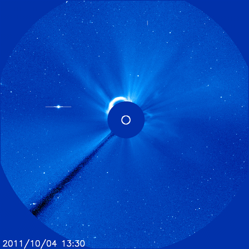
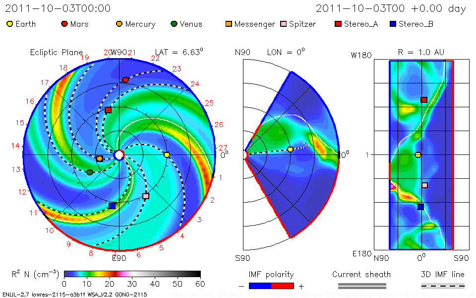
 While we have been enjoying the wonderful sunshine down on Earth (especially the recent record october warmth in the UK) - space has also been throwing up some pretty stunning weather. Yesterday, October 4th, a massive solar flare exploded from the surface on the far side of the Sun. It blasted a spectacular coronal mass ejection or CME into space. A CME is a massive burst of solar wind and plasma containing electrons and protons that blast out from the Sun's surface. They are associated with solar flares and tend to develop in areas of high solar activity such as Sun spots.
The October 4th CME was recorded by the Solar and Heliospheric Observatory
Scientists from the Goddard Space Weather Lab have plotted the course of the CME and discovered it is heading directly for the planet closest to the Sun, Mercury. The cloud of highly energised plasma and particles won't affect the planet but could disrupt the MESSENGER probe in orbit around Mercury.
It is possible that the CME may then hit Venus on Oct. 6th, but it is not predicted to hit Earth.

What happens when CME's hit Earth?
When CMEs do come our way the shockwave from the highly energized particles can cause a geomagnetic storm that can disrupt our magnetic shield. This can trigger dynamic auroras or Northern Lights [aurora borealis] in the northern hemisphere or Southern Lights [aurora australis] in the southern hemisphere. CMEs hitting earth can also cause disruption to radio transmissions, damage satellites and cause power cuts by knocking out electrical power cables.
They don't present a health risk for us on the surface because of our protective magnetic shield and atmosphere. But they can present problems for astronauts and even people in high altitude planes due to increased risk of exposure to radiation. But it is thought that any long-term health risk are unlikely.
http://www.bbc.co.uk/blogs/23degrees/