
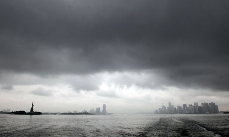
A panorama of New York's skyline taken as Hurricane Irene approaches. Photograph: KeystoneUSA-Zuma/Rex Features
Here's a summary of developments as Hurricane Irene heads towards New York City. The National Weather Center is describing it as a "large tropical cyclone" with "hurricane-force winds".
• Irene is lashing the eastern coasts of Virginia and Maryland with storm-force winds. There have been six confirmed deaths related to the storm. An 11-year-old boy in Virginia killed when a tree crashed through his roof and a North Carolina child who died in a crash at an intersection where traffic lights were out. In addition, a North Carolina man was killed by a flying tree limb, a passenger died when a tree fell on in a car in Virginia, and a surfer and another beachgoer in Florida were killed in heavy waves.
• About 1.5 million households in North Carolina, Virginia, Maryland, Delaware and DC are without electricity. The mayor of Philadelphia in Pennsylvania has warned citizens that outages could last for days, even weeks. As Irene heads north, that number is likely to grow.
From now, updates will be less frequent, with a full service resuming in a few hours.
North of us here in New York, the transit authorities in Boston have decided to shut the entire system from 8am. There will be no rail, bus or subway services after that time. The MBTA said it had made the decision after a "careful review" of the most recent information from the National Weather Service.
This is the latest satellite animation from the National Oceanic and Atmospheric Administration. It shows Irene tracking up the northeast coast of the US.
AP says the death toll so far in the US is six: an 11-year-old boy in Virginia killed when a tree crashed through his roof and a North Carolina child who died in a crash at an intersection where traffic lights were out. In addition, a North Carolina man was killed by a flying tree limb, a passenger died when a tree fell on in a car in Virginia, and a surfer and another beachgoer in Florida were killed in heavy waves.
At least three people died when Irene hit the Dominican Republic and Puerto Rico earlier this week. Back to Ewen Macaskill in Washington, who has been out on a second tour of the streets (stopping off for another beer).
Ewen's colleague in Washington, Suzanne Goldenberg, has a similar story: "It is certainly very wet, with rainwater coursing down the street, and there is bound to be flooding in some neighbourhoods, but no real strong gusts of wind yet. The city has felt a little quiet all day, but there are still cars in the road."Just got home after a second tour round DC. It is 10.10 pm, supposedly when the weather was to be at its worst in DC, but still no sign of a hurricane. It is wet but buses seem to be running as normal and plenty of taxis. The streets are quieter than usual because rain and some places, like the ice-cream shop, which would not have done much business anyway, have closed up. But there are plenty of bars and restaurants open.
There are a lot of trees lining the streets of Georgetown and I remember a storm a few years back when branches came down crushing cars: it took DC a week to clear some streets. Nothing like that so far: only saw one branch down that would have brained someone if they had been passing at the time.
I stopped off in my favourite Georgetown bar, Billy Martin's, for a pint of Guinness, and it was packed as it usually is on a Saturday night: all tables taken and all seats at the bar. Televisions tuned to the news for the hurricane, but those at the bar were unconcerned, at least as far as DC is concerned. But there were expressions of worry about it possibly "slamming into New York".
The 11pm update from the National Hurricane Center reports a storm surge of 4ft so far in Chesapeake Bay, and of about 5ft at Oregon Inlet in North Carolina. It describes Irene as a "large tropical cyclone".
Hurricane-force winds are located over a relatively small area roughtly 125 miles (205km) to the east of the center. Tropical storm force winds extend outward up to 240 miles (340km) from the center.It warns of rainfall of between six and 12 inches from eastern North Carolina northward into eastern New York and inland in New England.
These rains, combined with heavy rains over the past few weeks, could cause widespread flooding, life-threatening flash floods, and significant uprooting of trees due to rain-softened grounds.
We've focused a bit on New York – probably because that's where the big story will be tomorrow – but as shenanigans09 points out in the comments, the storm isn't here yet. Right now it's hitting Delaware, the eastern shore of Maryland and parts of Virginia.
There are several reports of tornadoes in Delaware. CNN reports that Kent general hospital in Dover, Delaware is being flooded, and staff are attempting to pump out the water – there are patients sill inside and they are battling to keep the electricity on. A note on the death toll. I said earlier (9.52pm) that there was confusion about whether it was five or eight. I think I've resolved the confusion. It's five in the US, and at least three more earlier in the Dominican Republic and Puerto Rico.
Meanwhile here's the full video of New York mayor Michael Bloomberg's statement.His office is pretty swift at putting these tapes on Youtube.
The mayor is asked, curiously, about whether he's heard reports of cab drivers hiking prices or store owners overcharging for bread. He says he doesn't expect it to be happening. "That's just not the New York way," he says. That was also the line he used in an earlier briefing when asked about the potential for looting.
He's also asked about why Rikers Island wasn't evacuated. He says that though it's in the evacuation zone A, it's higher than other places in that zone. Will he come to regret that statement?
Bloomberg says New York will get through the storm.
New York is the greatest city in the world, we will weather this storm. It don't think it matters if you're in a shelter tonight, or in your home, or staying with friends or family. We are all together in this. This emergency is bringing out the best in New Yorkers.The mayor says people should stay indoors tomorrow.
Tomorrow morning, when you wake up, whatever the conditions are , please stay inside. Too many things get blown around. Whether it's tree limbs coming down or porch furniture blown away, it's just not safe to be outside. It's cute to say 'I was outside during the storm'. But you're much better off staying inside and looking out.
Bloomberg says two kayakers were rescured from off the shoreline of Lower Manhattan. They were given summonses, he says. It was one of those "reckless acts" that diverted "badly needed" NYPD resources, he says. "Why they were out there, despite the warnings, I don't know."
He advises people to get away from windows because of the risk of debris. The risk rises above the 10th floor, he says. Stay out of glass lobbies, turn off propane tanks, and move to a room where there are as few windows as possible.
Mayor Bloomberg has emerged and is now speaking from City Hall, just down the street from where I am now. He confirms that a tornado watch is in force until 5am, "just to complicate matters".
The time for evacuation is over. Everyone should now go inside, and be prepared to stay inside until weather conditions improve, which won't likely be until Sunday afternoon. But we will get through this next 24 hours, I assure you.
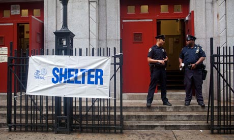 Police officers stand guard outside Seward Park high school, a desginated evacuation center for those forced to evacuate by hurricane Irene. Photograph: Andrew Burton/Getty Images
 In what may turn out not to be quite such the best timing, James Poland brought his girlfriend, Paula, from Ireland to New York to propose to her. She said yes, thankfully.
He emails to say: "We are now in our hotel with loads of beer and munchies having a hurricane party. Its like a pissing rain day in Dublin but Times Square seems to be preparing for the apocalypse." We're were due an update from the New York mayor, Michael Bloomberg, at 9.30pm ET, but he's more than half an hour late now. Shoulda kept the subway open a bit later, Mikey! Meanwhile lightening has just flashed over NYC. Irene is on her way.
I quoted CNN earlier saying that eight people had died because of Irene. But the latest roundup from Associated Press sticks with the earlier reported five deaths.
The deaths included two children, an 11-year-old boy in Virginia killed when a tree crashed through his roof and a North Carolina child who died in a crash at an intersection where traffic lights were out. In addition, a North Carolina man was killed by a flying tree limb, a passenger died when a tree fell on in a car in Virginia, and a surfer in Florida was killed in heavy waves.
From the comments below the line, a good even-handed post from a reader in Staten Island, worth reprinting in full, I think:
Since two years, I live at South Beach, Staten Island, looking out over New York's Lower Bay. I know something about the tides and currents in the bay. The day after tomorrow it is new moon; around full and new moon, tides are extra high and extra low. Tomorrow morning around 08:00 h local time, it will be high tide (combined with nearly spring tide).
Around the same time, Irene is approaching the Lower Bay, preceded by a stormy easterly, probably pushing the tide even more up and into the bay. I expect the combination of a high nearly spring tide and Irene's storm surge effect can indeed cause some serious flooding in low lying areas.
Then again, New Yorkers just are obsessed with threats and safety precautions. Early this evening, with Irene's arrival still more than 12 hours away, with a light breeze and a bit of drizzle, the police was already turning people away from making a stroll along the beach. An utterly useless waste of time and manpower and a needless harassment of peoples' liberties. This sort of paranoia for whatever kind of danger, seems to have become the norm, ten years after 9/11.
So what's the mood in New York? I think it's turning. It's all quiet here in Tribeca. Some of the bars are open but there aren't many customers about, and the rain is pelting down. I think people are starting to realise that despite all the jokes today, this could be serious.
Up from me in the West Village, according to Wilferooster on Twitter: "Not much worry about it from bars in the village, plenty staying open." He adds in another tweet: "Certainly the bars opposite Blue Note & those over a few blocks west are open & full."Over on the Upper West Side, Rachel Nuttall is "hunkered down with PG Tips and hobnobs" with "clouds ominously circling The Time Warner towers".
On Long Island, Jeff DelViscio says: "Irene not kidding around anymore on Long Island's north shore. Rain in sheets. Hydraulic steps forming in runoff on my street."
Amy Davidson, an editor at the New Yorker, has been spooked by the closure of the New York subway today. She asks: "Is there a scientific name for anxiety caused by lack of access to subways?"
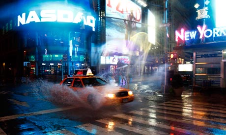 A taxi speeds by on 42nd Street at Times Square in New York as rains fall before hurricane Irene hits. Photograph: Peter Jones/Reuters
 My colleague Stuart Millar has been listening to the latest podcast from the National Hurricane Center, which says Irene is currently just offshore from eastern Virginia. It will move up the coast overnight and Sunday morning before making final landfall in southern New England on Sunday afternoon.
Stuart reports:The NHC said there was already lots of rain falling, with the heaviest to the west of centre of storm. Rainfall totals of 6-12 inches are predicted, though some areas may get up to 20 inches.
Strong winds are coming ashore towards the centre of the storm, and these winds are going to drive storm surge of 4-8 feet. In some areas, astronomical high tides, caused by the new moon, will make the impact worse.
Concerns are focused on the Norfolk, Virginia area. Southern Chesapeake is already experiencing near record rises of water, the NHC said. There are also concerns for Delaware Bay, coastal New Jersey, New York harbour and Long Island Sound.
Maximum winds are currently near 80mph, and the NHS predicted the storm would weaken slowly over the next 12-24 hours before rapid weakening as it passes over land. But hurricane or near-hurricane conditions will be felt all the way up east coast from Virginia to southern New England.
The National Weather Service has put New York on a Tornado watch. The conditions are "particularly favorable" for tornadoes to form in the area, it said.
My colleague Karen McVeigh visited an evacuation hall in Brooklyn earlier on. She noted that there was plenty of space and found one resident who reported that many of her neighbours were staying put.
Outside an evacuation centre in south Brooklyn, near her home in the waterside neighbourhood of Red Hook, Niyelle Manley said that a third of her neighbours were preparing to ride out the storm at home.You can read her full roundup here.
"We warned a lot of them but I guess they took it as a joke" she said. Manley, who arrived at the centre with her wheelchair-bound mother, Patricia and her two-month-old daughter, Kallyah, lives in the projects on the first floor of a block near the pier. She talked her mother into leaving, she said, but had no luck persuading seven or eight families out of 20 in her block who remained.
This interactive map from the power company ConEd shows where the latest power outages are occurring in New York.
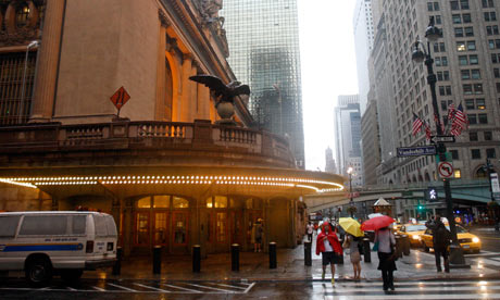 Pedestrians walk past Grand Central Terminal, New York, closed in advance of hurricane Irene. Photograph: Mike Groll/AP
 There's quite a debate going on in the comments below the line between those people who think Hurricane Irene won't have much of an effect and the media is overhyping it, and those who think that it's prudent to take precautions and that the potential for harm is great.
And it's not just divided between people from outside the eastern US and those who are here: many Americans – and in particular New Yorkers – think the media coverage and the political reaction has been over-the-top. The reaction of plumbtastic13 is not untypical:
This is a joke. To all that are genuinely concerned please don't be. This kind of media coverage is a constant here in the states. I am on the east coast in Jersey and some folks are scared but only because the NEWS makes them feel that way.But Renee12 says she's in an evacuation shelter in Brooklyn and has this disappointed response to those who have, in rather shrill tones, condemned the reaction of some.
Hi all. I am right now sitting in an evacuation center in NYC. I live in the Rockaways. Right there on the ocean ... I'm so sorry that the total catastophe that would have warrented media attention in your eyes hasn't happened...yet. Well, keep tuned. Perhaps the situation will become more dire.And then there's this from huntedmom in Philadelphia.
I'm not rich, just a single parent trying to survive in a bad economy. I don't have homeowners insurance because I can't afford it and also feed my children. Unfortunately, if I sustain damage to my home, I'm one American who won't be recovering quite as quickly as has been predicted.
CNN reports that eight people have now lost their lives since Hurricane Irene made landfall in North Carolina earlier today.
According to the National Hurricane Center, Irene has re-emerged over the Atlantic. It is warning that waters are rising in the Virginia tidewater region.
While I took a break from the liveblogging hotseat earlier, I went out for a walk around Tribeca, where I live, and down to the shore of the Hudson.
Night has fallen now, and the rain is lashing down. But a few hours ago, you can see from this video – usually teeming with ferries and other craft – that the river was as calm as a millpond. More on the growing concern over the New York mayor's attitude to Rikers Island. At a press conference earlier, he breezily dismissed a reporter's question about why the 17,000 prisoners on the island were not being evacuated, despite being in the evacuation zone.
Tonight, City Hall has put out a more reasoned explanation of why the inmates on Rikers are staying put. "Rikers Island does not touch the Atlantic Ocean and, like Manhattan Island, Roosevelt Island and City Island, it does not need to be evacuated, according to a spokeman for the mayor's office told the Wall Street Journal. While we gear up for a big night in New York, Irene will pass by the US capital, Washington, first. The Weather Channel is forecasting hurricane-force winds heading for Washington and Baltimore now.
Ewen Macaskill, our chief Washington correspondent, another Scot on the Guardian US team, has just been out for a walk around the streets. He reports:
Good evening and welcome to our continuing coverage of hurricane Irene's track up the Atlantic coast of the United States, with New York braced for a night of heavy winds and potentially damaging storm surges.
This is Matt Wells live blogging from Lower Manhattan – right in the middle of the area where the storm surges are expected to hit. Fortunately, I'm nine floors up.You can catch up with our earlier coverage here.
Here's a summary of events so far.
• Approximately 1 million Americans – in North Carolina, Virginia, Maryland, Delaware and DC – are without electricity. The mayor of Philadelphia in Pennsylvania has warned citizens that outages could last for days, even weeks. As Irene heads north, that number is likely to grow.
• Hundreds of thousands of people have been ordered to evacuate coastal and low-lying areas along the eastern seaboard. As many as 1 million people have left the Jersey shore. In New York City, Mayor Michael Bloomberg has warned that "we are going to break down doors if we have to" to enforce the evacuation.
• Transport has ground to a virtual halt on the east coast. Some 9,000 flights have been cancelled from affected airports. In New York, all public transport has closed down until Monday.
• Despite Irene losing force, downgraded to category 1, storm surges and heavy rains are creating danger of widespread flooding. In northern New England, Vermont's governor has declared a state of emergency, with flooding predicted in every river in the state.
Our guy Paul Harris (@paulxharris) has been out and about in downtown Manhattan, and just sent this bulletin:
The East Village, around 1st Avenue and 7th Street, certainly seems to bear up the idea that as far as wind speeds go Manhattan is being spared the sort of disaster people feared. Outside, it's currently very rainy with howling gusts of wind but there is little damage visible.We'll be watching that situation carefully and keeping you posted.
A few fairly large tree branches lie in the street but the local deli corner shop is still open. There was even a man taking his dog for a quick morning walk wearing a T-shirt and carrying a sturdy-looking umbrella.
But this area is a long way from the East River and the main threat to the city is the storm surge. No sign of flooding here at all. But that is to be expected. The main areas vulnerable to the storm surge lie to the south and east along the rivers.
We're expecting a Fema press conference at 11.30am ET from Washington, DC, with Homeland Security chief Janet Napolitano and Fema's Craig Fugate, to update the nation on the federal response to Hurricane Irene; we'll be covering that later.
WNYC reports that the East River is cresting its banks in lower Manhattan. Meanwhile my colleague New York business correspondent Dominic Rushe tweets that on West Broadway, in Soho (downtown Manhattan), water is reversing out of the grates and manholes and causing flooding there.But media commentator and Murdoch biographer Michael Wolff seems undaunted; he just tweeted:
Just went out for the paperHope he has a plastic bag for that – if he can find a copy to buy and a shop to sell it to him.
Progress of Irene can be followed via this interactive graphic.

New Jersey Governor Chris Christie tweets his interview on the Today Show. He reports that 15,000 people in New Jersey have taken up residence in the state's evacuation centres, while Today shows images of a grey, choppy Hudson River off Hoboken, across the water from Manhattan. Says the governor:
We've got record flooding in New Jersey. It's already happening … Inland flooding is at record levels. We've got people trying to leave their homes and we're getting distress calls from people in their cars being swept away by the water.He urges citizens of New Jersey to stay safe in their homes. He is asked about the nuclear power generator at Oyster Creek, NJ, which was shut down at 5pm Saturday. Christie says this was for "an abundance of caution" and there is "no concern at all" about the status of that power plant.
He confirms that 400,000 people in New Jersey are now without power.
I'm failing to embed that video here presently, but you can view it on YouTube.
Police officers stand guard outside an evacuation centre for Hurricane Irene. Photograph: Andrew Burton/Getty Images It's now light in New York City, or as light as it's going to get today. It's raining in Manhattan, but not torrentially right now; and the wind has abated. But that seems very likely to change as the storm system rotates, and the eye of the hurricane passes close to the city in the next few hours.
Via WNYC's Twitter feed, a public radio listener has posted this picture of the water rising in lower Manhattan in view of Brooklyn Bridge.According to NBC New York, fire fighters have been answering scores of calls during the night for utility polls, trees and power lines downed in Queens. ConEd (New York City's main power company) is now reporting 75,000 customers without power.
CNN is reporting that late Saturday night, a nuclear reactor at Calvert Cliffs, Maryland shut down automatically due to hurricane-force winds.
"The facility is safe; there is no impact to employees or our neighbors," [Mark] Sullivan [spokesman for the Constellation Energy Nuclear Group] said. "There is no threat."The company has not updated its news feed yet, so no word on whether that reactor has powered back up at this point.
My colleague Oliver Burkeman tweets that FoxNews has run a splendidly mistimed – or very well timed, depending on your point of view – opinion piece about what an outrageous waste of taxpayer dollars the National Weather Service is:
The truth is that the National Hurricane Center and its parent agency, the National Weather Service, are relics from America's past that have actually outlived their usefulness.I think a few tens of millions of Americans might beg to differ, just now.
Oliver normally resides in Brooklyn, but tells me he is safe and dry in York. That's old York, UK.
Latest tracking of the hurricane predicts that it will make landfall again at about 10am east of New York City, on western Long Island. That would be Nassau County, east of Queens, which happens to be one of the wealthiest counties in the United States – though, paradoxically, one hit by budget crisis. Earlier this year, the state government had to take control of the county's finances after it had essentially gone bust and its own officials could not agree a balanced budget.
No update yet from the Mayor's office or New York City government that I've seen, but no doubt the hyperactive Michael Bloomberg will be doing further pressers at some point Sunday. On Saturday, he told us that there was capacity for 70,000 people in evacuation centres. So far, the uptake has been modest: about 9,000 people have been spending the night in these centres, dotted throughout the metro area. To see their location, and the pattern of the evacuation zones, view this map (pdf).
According to WNYC, New York's public radio station, the storm surge has pushed the sea level up about 4ft above normal down at the Battery, which is at the southern tip of Manhattan in the New York harbour area. We're still a couple of hours away from high tide, which is due to be higher than normal in any case, thanks to a new moon.
It will be touch and go as to whether there is flooding around Wall Street – much may depend on the wind direction at the critical time, as I was hearing on WNYC last night: in the huge rotating weather system that is a tropical storm, you get winds in opposite directions in different areas. So, apparently, storm surges depend on whether the wind aligns with tidal flows in a given area. But I'll be looking for more expert metereological opinion on this. I'm working just a block or two from where this photograph was taken last night: a view up 34th Street, looking east, towards the Empire State Building. The rain is still pretty intense outside in Manhattan right now, although the rainfall radar here suggests that the heaviest precipitation is now across a huge area of New England. The hurricane just made landfall on the New Jersey coast a little while ago, still some way to the south and east of New York City. It's due through here at about 10am ET.
An overnight summary, as Hurricane Irene moved through the United States' Atlantic coast and the eye of the storm is due to hit New York this morning with heavy rain, hurricane-force winds and a storm surge:
• Overnight, the death toll has risen to at least nine. Five people were killed in North Carolina; three more died in Virginia, including an 11-year-old boy whose home was hit by a falling tree.• Hurricane Irene is moving north at 18mph, still a category 1 hurricane, with sustained winds of 75mph recorded.
• Nearly 3 million people are without power as the hurricane moves up the eastern seaboard. About 180,000 on Long Island are affected by electrical outages, with 30,000 people in New York City already without power.In neighbouring New Jersey, as many as 330,000 have had power cuts.
• More than 300,000 people have been evacuated from 'zone A' vulnerable areas in New York City. High tide at 8am in New York harbour coincides with the height of the storm, creating the risk of widespread flooding in low-lying areas.
• Lower Manhattan, including Wall Street, is threatened by storm surge flooding. Power company ConEd has said it will cut power pre-emptively if the flooding looks likely, possibly leaving the financial district without power going into Monday.
Welcome back to our live coverage of Hurricane Irene's progress, as the eye of the storm is expected to pass through New York City in the next few hours, and move north towards New England.
http://www.guardian.co.uk/world/blog/2011/aug/28/hurricane-irene-new-york-live-coverage1
Comments